
05Appendix
Unit of analysis
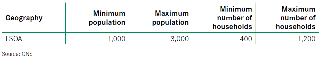
The spatial units used in the analysis are Lower Layer Super Output Areas (LSOAs). The statistics for LSOAs were originally released in 2004 for England and Wales and LSOAs are defined by the following minimum and maximum population and household thresholds:
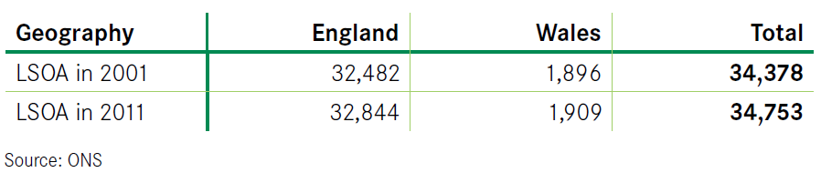
Where population growth over period 2001-2011 resulted in the population exceeding the maximum threshold, the LSOA has been split into two or more areas; if the population fell below the minimum threshold, the LSOA has been merged with the adjacent LSOAs. As a result, the count of LSOAs within England and Wales differs between the Census 2001 and the Census 2011 releases:
Three geographies: city areas
For each individual city in England and Wales, LSOAs were used to define three separate geographies:
- City centre
- Suburb
- Hinterland
City centre
The city centre is defined as a circular area, composed of all LSOAs that fall within a radius from a pre-defined city centre point. The radius is 2 miles for London, 0.8 miles for large cities and 0.5 miles for medium and small cities.
Where an LSOA only partially falls within this circular area, more than 50% of its land mass must fall within it for it to be classed as a city centre.
Suburb
Suburbs are defined as comprising all LSOAs within the respective Primary Urban Area (PUA) that are not classed as city centres LSOAs.
Suburbs of different cities do not overlap, as these are perfectly nested within the local authorities that make up the PUA.
The Primary Urban Area (PUA) definition is a standard statistical geography which reflects the continuous built up area of a city. It is defined for English cities only. For Welsh cities, a city definition is based on the corresponding local authority area.
City centres and suburbs combined make up the PUAs.
Hinterland
The hinterland is defined as a circular area, composed of all LSOAs that fall within a certain radius from the pre-defined city centre point. This radius is city-specific and depends on the average distance travelled by those who live outside of the city but commute into the city.
The average distance travelled figures are calculated in reference to Middle Layer Super Output Areas (MSOAs) rather than LSOAs, as commuting data for LSOAs would have been too complex to analyse. The MSOA-based average distance travelled figures are likely to be similar to the LSOA-based figures.
Where an LSOA only partially falls within this commuting radius, more than 50 per cent of its land mass must fall within it for it to be classed as a hinterland. By definition, the city centre or suburb of one city cannot be classed as the hinterland of another city, even if they fall within the commuting radius.
The hinterlands of different cities overlap and some non-urban LSOAs belong to a hinterland of more than one city, making it impossible to report the statistics for hinterlands of individual cities without double counting. However, the statistics that are reported for the hinterlands in total do not double-count LSOAs.
Travel to Work Areas
In the report, a bespoke definition of a hinterland is used, based on an average distance travelled by those who live outside of the city but commute into the city. Although there exists an alternative definition of commuting areas based on the Travel to Work Areas (TTWAs), which captures a set of non-overlapping labour market areas, this definition is not used in the analysis for the following reasons:
- TTWAs are non-overlapping and contiguous areas, and do not capture the possibility that a single location offers an easy access to multiple PUAs.
- TTWAs do not necessarily use cities as their centre point and sometimes are defined for a collection of two local centres of employment (e.g. Newcastle & Durham rather than Newcastle itself).
The rural hinterlands based on the average distance travelled employed in this report are defined for a single PUA. This better captures the relationship that rural areas may have with more than one urban area, especially important in areas with a large concentration of cities.
Adjustments to city centre definitions
The criterion for allocating LSOAs to city centres was that more than 50 per cent of the land mass must fall within the circular areas of defined city centre (which as explained above, varied by city size). Owing to the LSOA boundary revisions detailed above, city centre definitions also differed between 2001 and 2011.
Adjustments were therefore made to the city centre definitions to ensure full comparability of data across time periods. Where the boundary of city centres differed between 2001 and 2011, adjustments were made, involving adding or removing individual LSOAs to or from these definitions. The adjusted city centre definitions cover the same land area of cities in 2001 and 2011.
Four categories of cities
The analysis distinguishes between four types of cities:
- London
- Large city (population is more than 550,000)
- Medium city (population is between 230,000 and 550,000)
- Small city (population is less than 230,000)
Based on the size of resident population in 2011, 59 cities within England and Wales were allocated into the above categories as follows:
